| City, town or village | County | State | Country | Elevation |
| Devils Den | Kern County | California | USA | 505 feet (154 meters) |
| Latitude (DMS format) | Longitude (DMS format) | Map on which this town can be found |
| 35° 45' 56"N | 119° 58' 29"W | Avenal Gap |
Devils Den is located in Central California,
in the northwest corner of Kern County,
just south of the Kings County line. The
nearby Devil's Den oil field is located to
the west of highway 33 and south of Devil's
Den Road.
Origin of its unusual name
According to the book, Kern County Place
Names, by Curtis Darling, Devils Den,
California was named for an unusual volcanic
formation found four miles to the west.
Nearby cities and towns:
San Miguel, California (to the west)
Coalinga, California (to the northwest)
Hanford, California (to the northeast)
Delano, California (to the east)
Bakersfield, California (to the southeast)
San Luis Obispo, California (to the southwest)
Time Zone: Devils Den, California is in the Pacific Time Zone.
Plant Hardiness Zone: 9a
Visit our page of U.S. plant hardiness zones for
a look at maps showing all hardiness zones throughout
North America.
Over the years, points of interest in the region have included:
* Mission San Miguel, in San Miguel, California
* San Simeon State Park, San Simeon, California
* Tule Elk State Reserve, west of Bakersfield, California
* Pixley National Wildlife Refuge, south of Tulare, California
* Colonel Allensworth State Historic Park, Allensworth, California
* Kern National Wildlife Refuge, east of Devil's Den, and west of Delano, California
Recreational opportunities in California's Central Valley:
Camping, fishing, hunting, picnicking, hiking,
birdwatching, photography, golfing, sky diving,
off-roading, kayaking, rafting, mountain biking,
boating and horseback riding.
Some of the wildlife found in the southern San Joaquin Valley:
Fox, bobcat, coyote, opossum, raccoon, weasel,
badger, skunk, squirrel, muskrat, beaver, jackrabbit,
tortoise, pheasant, falcon, duck, geese, quail, pelican,
dove, owl, warbler, oriole, goldfinch, woodpecker,
starling, swan, heron, egret, sandpiper, hawk and
eagle.
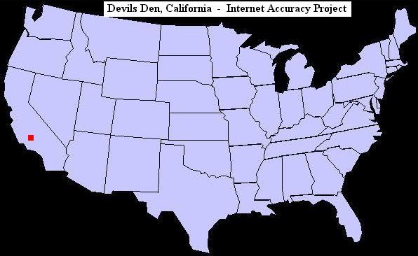
U.S. map showing the location of Devils Den, California
For an extensive list of other odd town names in the
United States, visit our page of unusual, bizarre or humorous names of towns.
|